A
Tale of Two Cats
(there has to be a bad pun
in there somewhere,
if I can just figure it out!)
by Jamie
Orr
In June, Chuck Gottfried sent me an
email saying he and Rollan, his bro-in-law, were cruising
the San Juan Islands in early July, and wondering if Wayward
Lass might find her way over there. We’d met at
the Depoe Bay boat show, so we’d seen each other’s
boats before, but we hadn’t seen them in action.
Chuck has a 15.5 foot (it seems bigger!) Thomkat that
he built – a real classic type catboat, barn door
rudder and all. Wayward Lass is a Chebacco cat yawl –
I don’t know if that qualifies as a “real”
catboat, but she’s close enough for me.
After trading some emails, we agreed
to meet at Sucia Island – it’s a small State
Park with lots of bays and anchorages, right at the north
end of the San Juan group. It’s also within easy
reach (about 25 miles) of Sidney, where we often launch.
This was important as I only had two days for the trip.
I’ve added a map, courtesy of Mapquest, at the end
of this epistle for those who don’t know the area
(most of us!)
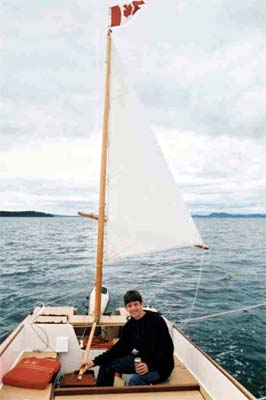
My almost fifteen year old son Alan
came with me. We started on the Monday evening, leaving
the dock in Sidney about ten to seven. We had to use the
motor as there was no wind at all, despite earlier predictions
of 15 knots in Haro Strait. We headed northeast around
Sidney Spit, then just south of east across the strait
for Roche Harbor. It was a straightforward run, and we
arrived just after nine – we lost a few minutes
when a breeze sprang up and we raised the sails, but the
breeze didn’t last. We cleared customs in Roche
Harbor, then had a look around. Nice, but Roche Harbor
Marina is a pretty upscale sort of place – lots
of big three-story power cruisers with acres of white
fibreglass and big tinted windows. Wayward Lass felt a
bit out of place there!
Since it was getting late, we stayed
at the dock for the night. We were up about seven the
next morning for our on-board pancake breakfast. We wanted
to ride the flood tide to Sucia, so we cast off just before
nine, with barely enough wind to let us steer around the
boats anchored in the bay. The current helped to move
us north out of Roche Harbor though, then east along Spieden
Passage. The wind was very weak and fluky, letting the
eddies occasionally spin us around, but no matter which
way we were pointed, the current kept us moving eastward.
About halfway through the passage the wind woke up and
we started to sail properly. Travelling east with a southeast
wind, we were close hauled in the pass, and couldn’t
quite clear Spieden Island in one tack. However, when
the Washington State ferry came by on its way to Sidney,
it seemed to really want the north side of the channel,
so we put in a short tack to the south, and after that
we could scrape past Green Point at the east end of the
island.
As we cleared the point, the wind rose
to maybe 15 knots – if we’d still been beating
I would have thought about reefing. However, our new course
was slightly east of north, to pass north of Waldron Island,
so that put us on a reach – and with the north-going
tide helping, we flew right along! A McGregor 26 came
up from San Juan Channel, planing under power. While we
watched, her motor slowed, came back, then slowed and
stopped for good. We didn’t know if they were having
problems or not, but no one signaled for help, so we kept
on. After a few minutes, they put their sails up and they
got under way again, a little more slowly than before.
I can’t say I was impressed by the sailing performance
though – despite their longer waterline we kept
drawing further ahead for as long as we watched. I don’t
know whether the McGregor is that slow, or maybe the owner
doesn’t sail much. Of course. I prefer to think
we have the better boat – and you know I’m
not prejudiced!
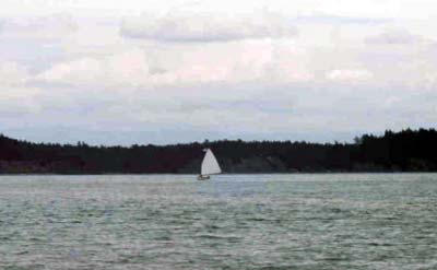
Here’s a shot of Alan sailing
Wayward Lass to Waldron
The wind seemed to be linked to some
rain clouds passing just south of us – as we rounded
Waldron and passed Skipjack Island, we moved out from
under their shadow, and exchanged our sailing breeze for
bright sunshine and much lighter air. Through the binoculars,
I could see a single gaff sail to the east, against the
dark background of Sucia – we thought that might
be Chuck and Rollan. We’d arranged to start monitoring
the cell phone and VHF at noon, and it was just about
that now, but I received no answer on either when I called.
However, just a minute later the phone rang, and it was
Rollan calling us. They could see us, and had the advantage
of some wind, so they ran down to meet us. Alan and I
were almost becalmed by now, but Tabby had the wind behind
her – at least for a while.
Tabby’s getting nearer…
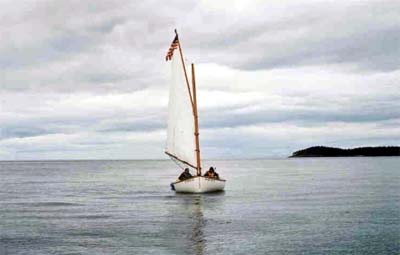
And nearer…
And here she is!
We came together about 1:00, and sailed
along in company – by then Tabby had used up the
best of the wind, leaving us barely enough to steer by!
We swapped news as we went, then Chuck decided to head
into Fox Cove for a late lunch, so off they motored. Alan
and I thought we’d try a bit longer to finish our
journey under sail, since we’d had such a good day
so far. It took another hour, but we managed it, dropping
the anchor a few yards upwind from Tabby about 2:30. We
paid out rode until we drifted down far enough to raft
up, then settled down to swap beer and bull. Alan pumped
up our little inflatable for a trip around the bay –
hard work since it doesn’t row all that well. Chuck
and Rollan have an inflatable kayak/canoe that goes a
lot faster, but they said it can be tippy until everyone
is properly seated. Besides, the dinghy folds into one
of Wayward Lass’ stern locker with room to spare,
so we’ll stick with it for now. (BTW, both inflatables
are by Sevylor, and both appear to be good value for the
price.)
After a while, an older gent rowed up
to chat about sailing and catboats. His sloop was anchored
in False Bay, one anchorage over. He was still visiting
when the wind came back again and we decided to go for
a sail, so we offered him a ride back to his boat, which
he accepted. We all went in Wayward Lass, since Chuck
is also building a Chebacco but hadn’t sailed in
one yet. We had a nice sail for a while, but it didn’t
last, and we finally had to call on Honda to finish the
job. After we dropped our guest at his boat, we headed
back to our cove for dinner. Alan and I had spaghetti
with some great homemade sauce, then we went ashore to
toast marshmallows and fool around on the beach. After
that, it was time to hit the sack – a lengthy process
when the cabin has to be cleared of all gear to make space
for our beds! A couple of mosquitoes showed up, so we
hung our nets to guarantee an undisturbed night.
Wednesday started disgustingly early,
because we wanted to take the ebb tide west and south
to Stuart Island, north of Roche Harbor. The current atlas
showed a strong ebb from 3 to 9 am, a flood from about
10 am to 4 pm, then short and weak ebb from 5 to 7 pm.
We’d all agreed to get up at three, to give ourselves
time for a decent breakfast and to use the facilities
ashore, but at 3 o’clock there wasn’t a breath
of wind, and I was wondering if this was a really dumb
idea. Bit we went ahead anyway, getting the anchors up
shortly before 5:00, and by 6:00 the sun was warming our
backs and my cowardly second thoughts were forgotten!
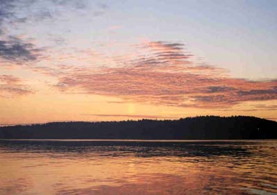
Sunrise over Sucia
Tabby has a 2 hp motor, so she set the
pace. I guessed the motors were giving us about 3 knots,
but we had that strong ebb working for us once we got
near Waldron. In the pass between Waldron and Skipjack
the current was very strong. Both of us noted the speed
over the ground was over 8 knots by GPS, (I saw 8.2, and
Chuck, who was watching more closely, recorded a high
of 8.8) which meant about 5 knots of current helping us
along. The speed dropped once we were clear of the passage,
but remained up in the 6 and 7 knot range for much of
the way to Stuart. Just as well we didn’t sleep
in and have that kind of current against us later!
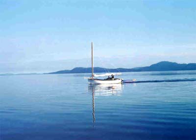
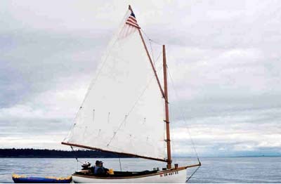
Tabby on the way to Stuart Island
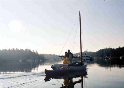
Coming in to Prevost Harbor
We arrived in Prevost Harbor at Stuart
just before eight, and tied up at the Park dock.
We took a stroll across the narrow neck
of the island to see Reid Harbor on the other side, then
sat around drinking Tabby’s tea and chatting some
more – except for Alan, who had crawled back into
his sleeping bag not long after we left Sucia. He managed
to log an extra four hours before he woke the second time!
Once he was fed (teenagers burn a lot of fuel!) and more
or less functional, he and I thought we would start back
to Sidney. We said our good-byes to Chuck and Rollan and
pushed away from the dock about 11:30, hoping to recapture
our luck of the day before – but it wasn’t
to be. We eventually ghosted out far enough to catch what
little breeze we could see ruffling the harbour waters,
but it didn’t extend beyond the headlands, and an
hour or so after leaving, we gave up and took in the sails.
Honda came to the fore again, and took us back to Sidney
in another two hours.
The overlapping stone breakwaters at
the Port of Sidney conceal the entrance very effectively.
I was steering for the entrance marker, looking for the
opening through binoculars, (without much success) when
a power boat suddenly materialized as if from the stone!
Once inside, at the customs dock we found a just-barely-big-enough
space between two monster power cruisers, and achieved
a very creditable landing through some nice teamwork.
As we swung in, the starboard quarter was tucked well
under the overhang of the bows behind, the mizzen sliding
past the pulpit/anchor-roller/bowsprit with about six
inches to spare. Clearing customs only took seconds, and
we were off again, this time for the boat ramp. The recovery
went just as smoothly, and soon we were unrigged, unpacked,
and on the road home – a good finish to the journey.
Alan and I agreed that it had been a good trip all around,
even worth getting up before dawn!
Thanks to Chuck and Rollan for
suggesting it!
Jamie
Orr
Where we were….
Sidney to Sucia = Red line
Sucia to Sidney = Yellow line
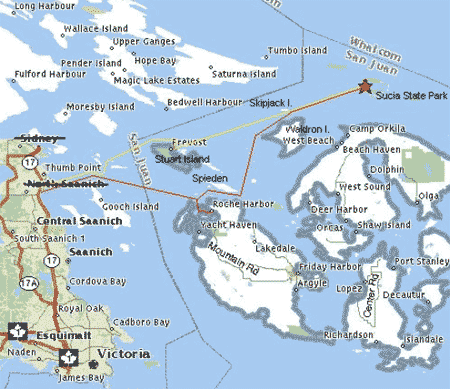
Sidney to Roche Harbor is about 10 miles,
and Roche to Sucia, about 15. The homeward leg was shorter as
we didn’t detour to Roche Harbor. You’ll notice
I’ve edited a couple of place names – Sidney is
actually about where North Saanich (crossed out) is shown. And
what the map calls Gooch Island is Sidney Island – it
has a long spit to the north that is written over, but you can
roughly see where it ends by the bend in our outward bound track
(the red line).