|
Savannah to Charleston 2005 |

|
|
By Samuel W. Norwood III - Atlanta, Georgia - USA |
Below is "Woody" Norwood's account of a cruise he took last year. It got so much attention that he is organizing a group cruise for Classic Boats. This event will be from April 28 to May 3. More info HERE. If you are interested, contact Woody at snorwood@mindspring.com or call 404-352-9536 |
Adventure
For many years I have dreamed of having a long distance adventure in a sailboat. Inspired by the books of Joshua Slocum and Tristan Jones and others who ventured in small craft around the world, in the presence of my mid-life crisis in the late 1970s and early 1980s, I longed to quit my job and set sail for at least a year or two to live the life of a transient sailing vagabond. I collected and read dozens of books about doing this, and I went through divorce after nineteen years of marriage. Finally, reality set in. I did not really want to do this alone, and I realized that I have no particular skills in engine maintenance or any occupation that could create financial income during such a voyage or lifestyle. I was a corporate planner by trade, and I had a fear of poverty. Contrary to romantic views sometimes expressed in the books, sailboats are expensive to own and maintain. I visualized, with some dread, myself in Singapore with a cardboard sign that read, WILL STRATEGIC PLAN FOR FOOD AND SAILBOAT PARTS. Finally, the burning need to head off the sea in a sailboat declined to a simmer, and I turned my energy back to earning a living and doing mild adventure hikes in the Alps on vacation.
But, the flame to do an adventure in sailing never went completely away.
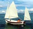
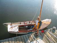
I have just completed a little sailing adventure that could be done by anyone with a small sailboat and reasonable sailing and navigational skills, without quitting my job, without breaking the bank, and without even the potential discomforts of sleeping on the boat. I sailed my Herreshoff 12 ½, “Myrdie”, from Savannah, GA to Charleston, SC, a total of 140 miles, on the IntraCoastal Waterway (ICW) in six days (including a lay-day in Beaufort). Blessed with superb weather, with the prevailing wind from the southwest, and by timing the departure each day to take advantage of the tides, my adventure was a combination of fun, beauty, learning, and just enough of an adventure to bring huge satisfaction. My wife (not the first), Alice, met my crew and me every night to shuttle off to dinner and comfortable sleeping accommodations. In the morning, Alice would deliver us by car to the boat, where we would sail off on the next leg of the adventure, and Alice would have the day free for touring and shopping in the historic towns of Savannah, Beaufort, and Charleston.
The Herreshoff 12 1/2
The Herreshoff 12 ½ (“H-12”) was designed by Nat Herreshoff in 1914, and the currently produced H 12s are little changed from Herreshoff’s original. “Captain Nat” Herreshoff dominated yacht design from the 1880s to the 1920s, designing and building all of the America’s Cup defenders during a span of almost forty years. The H-12 (12 ½ feet on the waterline, 15’9” LOA) was intended to be a training boat for future yachtsmen, but it has proven to be exceedingly popular for racing and day sailing, especially in New England. The original ones, produced at Herreshoff Manufacturing Co. in Bristol, RI, of wood until the company shut down in 1947, are cherished collectors’ items. The molds for the H-12, and the rights to the name, were bought by Cape Cod Shipbuilding Co. of Wareham, MA. In the 1950s, Cape Cod Shipbuilding started making the H-12 in fiberglass while preserving the classic beauty of Herreshoff’s design by continuing to use ample mahogany and teak trim and spruce spars. The boat is available in gaff or Marconi sloop rigs. Cape Cod Shipbuilding has built about 500 of these boats, as has another builder, Bill Hardin, of a version called the “Doughdish” just down the road, in Marion, MA. These boats are perfect for the sounds, bays, and estuaries of the coasts as they are very seaworthy for their length.
The first H-12 I ever saw was on a trip to Mahone Bay, Nova Scotia to visit friends in the summer of 2003. Bill and Kerstin Gilkerson had moved to Nova Scotia from Marion, MA ten years previously. Bill is a well-known marine artist and the author of several books, and he is considered one of the world authorities on scrimshaw and on fire arms used on ships in the days of sail. Kerstin is a Swedish former model with Neiman Marcus who had been a friend of my wife, Alice Lynch, since their college days at the University of Texas. Bill and Kerstin owned a Doughdish that they keep in the water in front of their home on Mahone Bay during the summer months. Kerstin said she would sail in her boat nearly every day during the summer months. She invited Alice and me to go for a sail. When we got away from the dock I took the helm and within minutes I was hooked. I loved this boat. It is hard to describe the attraction, but it is like putting your feet into the perfect pair of shoes. It looked right, but more importantly, it felt right. It was like love at first sight.
“Myrdie”
When I returned home to Atlanta I immediately started a search on the Internet to find a used H-12. There were very few, and those that were available were priced nearly the same as a new one. After two months of searching for a used on I gave up and decided to have one built. I took a trip to Massachusetts and spent the better part of two days going back and forth between Cape Cod Shipbuilding in Wareham and Bill Hardin’s facility in Marion. I ultimately decided in favor of Cape Cod, but it was a very close decision and I am confident that I would have been happy with either choice. Construction on “Myrdie” (the name I gave the boat after my nickname for Alice) began in January 2004. It takes Cape Cod about a month to do the fiberglass lay-up and attach the keel (which weighs about 750 pounds). Then, it takes about four months in the wood shop. Wendy Goodwin, VP of Cape Cod and fourth generation of the company’s owning family, sent me pictures periodically of Myrdie’s progress. I took delivery in June.
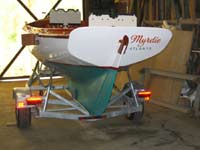 |
Construction on “Myrdie” (the name I gave the boat after my nickname for Alice) began in January 2004.
(click images for larger views) |
|
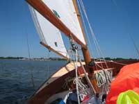
After sailing Myrdie on the coast of Maine and Nova Scotia and then on the Georgia coast near Sea Island and Jekyll Island in the summer of 2004 I started thinking again about making an extended voyage in my H-12. The ICW is beautiful from Virginia to Florida, and the boat seemed made just for these waters. Drawing only 2.5 feet, the H-12 can operate in shallow waters. With the gaff rig, which I have, this boat can sail under any bridge with 16 feet or more of clearance (21 feet with the Marconi rig or with the gaff fully up). I bought a set of charts and started studying the ICW.
The IntraCoastal Waterway
The ICW was created during World Wear II to enable commercial ship and barge traffic to move up and down the coast without being exposed to Nazi U-Boats which threatened open water coastal transportation. After the war, much of the transportation again moved offshore. With the reduction of commercial traffic, the US government has been less and less inclined to keep the channel dredged to the “guaranteed” 16 food depth. With less dredging in the past twenty years, parts of the ICW are getting “silted in”, with parts of the channel barely six feet deep. The silting has caused further reductions in commercial use of the ICW due to increasingly frequent groundings by commercial craft. The net result is that most of the traffic on the ICW is, by far, recreational. Under current trends, it might not be many years before the much of the ICW will not be an option for commercial traffic at all and of only limited use for boats drawing over five feet of depth.
Savannah to Charleston: The Idea
The idea of Savannah to Charleston grew from a study of the ICW charts and also the history and romance of these two beautiful cities. The town of Beaufort, SC is roughly half way between Savannah and Charleston, and it also is historically significant. This is the heart of the “Low Country”. Having read all of Pat Conroy’s books (see especially The Prince of Tides, The Water is Wide, and The Great Santini) and having visited these towns some over the years, I was familiar with the great seafood (did you see the movie “Forrest Gump”?), and the friendly hospitality of the area in addition to its profound physical beauty. Beaufort was also the location for the filming of “The Big Chill”.
In November 2004 I took Myrdie on her trailer to Beaufort to try a week of sailing up and down the ICW. Beaufort is historically more significant than I had known. By the middle of the eighteenth century The Low Country had become wealthy on the basis of rice, indigo and cotton. For nearly a century, until the Civil War, Beaufort was, in effect, the Newport of the South. The wealthiest plantation owners built homes in Beaufort, and about seventy of these antebellum homes are still standing and in use today. Today, Beaufort is a quiet town of about 10,000 in population. It is not wealthy, simply quiet with a slow pace. Not much has changed in Beaufort in the past 50 years. Hilton Head, just to the south, is a booming golfing resort with snarls of automobile traffic. If Beaufort has a golf course they hide it well. Rush hour in Beaufort lasts about fifteen minutes. When Barbara Streisand came to Beaufort to film The Prince of Tides she like it so much she bought a place there.
I launched Myrdie at Beaufort’s Downtown Marina and secured a room in the Best Western “Sea Island Inn” right across the street from the marina. Each day, I ventured up and down the ICW. From Beaufort I can get to the sounds in either direction in a couple of hours. Sailing south down the Beaufort River beside Parris Island (Marine base camp) I can reach Port Royal Sound in a couple of hours and sail across the sound to the north end of Hilton Head in another hour or two depending on the wind and tidal current. By sailing north on the Beaufort River, I can reach the broad expanse of the Coosa River in an hour or two, and this empties into St Helena Sound.
Beaufort’s charms captivated me. At dinner with Frank and Marilyn Pontious, friends who had moved from Atlanta to Beaufort, I told them how much I liked the area. Marilyn handed me the local newspaper and said “take a look at the home ads”. Back at the Sea Island Inn, I scanned the ads and found a town home for sale with a dock on the ICW. I called Alice on the phone and told her what I wanted to do. She supported the idea. I bought the town home.
Alice thinks of Myrdie as my girlfriend. In order to take Myrdie around with me I had to buy her a car (my other car was not quite big enough), and then I had to buy her a home. I buy stuff for her all the time, and I do spend quality time with Myrdie. Alice has a point.
The outline of the adventure from Savannah to Charleston then began to take shape. I would do it in five one-day legs.
- Savannah to Hilton Head
-
Hilton Head to Beaufort
-
Beaufort to Edisto (Island) Marina
-
Edisto Marina to Seabrook Island (Bohicket Marina)
-
Bohicket Marina to Charleston
The tidal currents in the Low Country run 2 to 4 knots, sometimes to 6 knots. An H-12, with its 12.5 foot waterline length, has a hull speed (maximum speed that the hull can sail through the water) of about 4.75 knots. Effectively, what this means is that little, if any, progress can be made if both the tide and the wind are coming from where you want to go. Therefore, two things became obviously very important. First, I had to plan the trip for a time when I could count on the tides going mostly my way. Second, a reliable outboard motor would be needed to deal with possible adversity in terms of tides and wind (including lack of the latter).
Day 1: Savannah to Hilton Head
My brother-in-law, Bill Tumlin, agreed to sail with me for the first two days. A native of Marietta, Bill grew up sailing at the Atlanta Yacht Club as I did. When Bill graduated from University of Georgia, he married my sister, Beth, and they have raised three outstanding daughters. They are a sailing family, having won regattas in Thistles, Snipes and Y-Flyers. Bill and Beth have been the Atlanta Yacht Club champions many times, and Bill has served AYC as commodore. If we had gotten three or more H-12s to do this adventure together, Bill would have brought over his motorboat and served as race committee and rescue. I actually tried to get other owners of H-12s to join in, but there were no takers. So Bill was with me from Savannah to Beaufort, the first two days.
On Sunday, April 24, as guests of Olin McIntosh at the Savannah Yacht Club, we, with the able direction of Dockmaster Sam Collins and his assistant, Ron McCain, as well as club member Lamar Walter, launched Myrdie at 9 AM. Small Craft Warnings were posted under the slate skies, and the day’s wind was expected to be 15 to 35 MPH out of the west. At launching we had a solid 20 MPH. We reefed the mainsail as we put it up. The locals were very concerned for our safety. Lamar offered us a bigger can of gas for our 2 HP Honda outboard. We declined, as the Honda can run all day on the gallon we took with us (and, in fact, we used less than a gallon during the entire trip). Then Lamar offered us portable running lights in case we were to get stuck after dark. Again we declined. With this wind we figured to be in early. They all asked if we had ever tried to cross the Savannah River to Fields Cut in this kind of wind. They shook their heads when we told them we had not yet been on the Savannah River or up Fields Cut. Sam told us about the last marina we would see before committing to the Savannah River, after which there would be no source of help for many miles until Daufuskee Island Lodge.
The wind was filling in behind a cold front that had passed through the previous day, and the temperature was in the low sixties. Bill and I had put on our full foul weather gear when Lamar noticed that Bill was without gloves. Bill gratefully accepted Lamar’s kind and trusting offer of a pair of gloves and a strap with clips to keep his had attached to the collar of his coat. The concern of the local folks about our safety raised my wife’s level of anxiety about our adventure. She suggested that we wait a day. I felt a little like Gary Cooper shrugging off his girlfriend’s concerns as he walked away to meet the bad guy in a shootout at High Noon. Finally, amid anxious looks from not only the locals but, more importantly to us, our wives, Bill and I shoved off with the little Honda purring and only the mainsail hoisted and reefed.
In the channel both the wind and the tide were against us. After we cut the engine we realized that without the jib up we would not be able to make progress. Looking to the stern, we realized, too, that the tide was moving us backward toward the Savannah YC docks despite the fact that we were moving forward through the water. So we cranked the engine again and started moving forward. Then we hoisted the jib and cut the engine. We were sailing!
Exhilarated, we sailed up the tide on the Wilmington River, hard on the wind. Against the out flowing tide it took an hour and forty-five minutes to reach the Thunderbolt Bridge, just 2.5 nautical miles (nm) from the Savannah YC. Past the Thunderbolt Bridge, we sailed past the Bonaventure Cemetery, made famous in the book, Midnight in the Garden of Good and Evil. As the river curved northward we started moving faster on a port tack reach. We saw our wives again as we sailed past the last marina. In another hour Bill and I passed under the Causton Bluff Bridge just two nm further up the Wilmington River. The tide changes just past at the Causton Bluff Bridge, and the river turn east, so now we started getting help from the out flowing tide as well as a broad reach angle to the wind. We weren’t just sailing, we were flying toward the Savannah River.
As we approached Elba Island Cut, between Bird Island and Elba Island, we had a near disaster. Silt had filled in the channel, and we did not notice that a temporary red buoy had been put out to direct northbound traffic to the right. Suddenly we hit bottom, a soft mud that brought us to a halt. The boat heeled sharply to starboard as both the wind and the tide were pushing from the port side quarter. Myrdie tried to round up to windward under all the pressure, and that drove us further in the wrong direction. Bill was hollering to steer back downwind (to the right) but we were hard on the shoal, and the boat would not turn. We lowered the mainsail to reduce the pressure. Then we both got out of the boat to push off the shoal. Big mistake. It was dumb for both of us to be outside the boat at the same time, but at that moment, it seemed like the only way out of our predicament. We got the boat off the shoal, and suddenly we were in deep water, over our heads, and the boat was sailing off under the jib with Bill and me both hanging on, our bodies dragging outside the boat. We were heading straight for the Savannah River in 20 MPH winds, hanging on for dear life. Bill is sixty years old and I am sixty-four, and neither of us is in particularly great shape. Our soaking foul weather gear seemed to weight a ton. My life jacket was one that self-inflates when it gets wet and, inflated, it posed a hindrance in being able to hoist myself into the boat. From the outside I was able to steer us to the far side of the cut, and when we got close enough to stand up, Bill boosted me up to a point where I could roll into the boat. Then, I got Bill’s leg and pulled him up and into the boat. We just sat there for a few minutes, recovering our composure as the jib luffed madly in the wind. Then we hoisted the mainsail and sailed out into the Savannah River.
We found the Savannah River to be easily manageable with the wind and tide going fundamentally in the same direction. No problem with Fields Cut and Walls Cut to Ramshorn Creek. We hit the highest sustained winds of the day and week, however, where New River comes into Ramshorn Creek. The wind slotted right down New River at 30 - 35 MPH. Bill was at the helm, and even by feathering both sails on a port tack reach, with the main reefed, I felt that this was getting close to the maximum that these boats are designed to be sailed in.
Sailing along Daufuskee Island was wonderful. Daufuskee was made famous in Pat Conroy’s book, The Water is Wide, in which the author is a teacher of black children who had never been off the island. Even today, the only way to reach Daufuskee is by boat. It is being developed, however, and I understand there are three golf courses. There is a growing population of retirees and second homes. The name comes from the way the Gullah natives originally described it as “the first key” (“key” means island, as in Key West).
At the north end of Daufuskee, Bill and I swung southeast and entered Calibogue Sound, heading for the highly visible red and white striped lighthouse at Harbour Town on Hilton Head Island. The marina welcomed us with a bottle of wine and guided us to our assigned slip for the night. We tied up at 4:30, washed down the boat, put on the cover, and, with our wives, who arrived with the car just as we did with the boat, drove off to Savannah for a hot shower and a seafood dinner in the Historic District.
If you have not read Midnight at the Garden of Good and Evil, get a copy and learn about Savannah’s history and society. It is a mystery novel in a modern setting. Savannah was laid out by the first governor of Georgia, James Oglethorpe, in the 1730s. The unique layout in the Historic District is characterized by small parks and squares. In the Civil War, Savannah was spared from burning by General Sherman who burned most of the state in his march to the sea that was influential in bringing an end to the war. Savannah has hundreds of homes that date back to the era before the Civil War. We stayed in the Colonial Park Inn on East Liberty Street, a delightful B&B that had been built in 1850.
Day 2: Hilton Head to Beaufort
If Day 1 would be characterized as “adventurous” day 2 would be characterized as “a perfect day of sailing”. The wind had declined to a range of 10 to 12 MPH but remained out of the west. We wanted to plan the day so we would cross Port Royal Sound at low tide and then have the incoming current with us as we sailed up the Beaufort River 8 nm to Beaufort. This meant we would have an adverse tide as we sailed out of Harbour Town, north on Calibogue Sound parallel to Hilton Head, but we figured this would be less consequential than having adversity going up the Beaufort River against the tide in the late afternoon.
| If Day 1 would be characterized as “adventurous” day 2 would be characterized as “a perfect day of sailing”. |
|
|
Bill and I departed Harbour Town at 11 AM and stowed away the Honda as soon as we cleared the harbor. The motor comes off its bracket easily and stows under the port side seat. Progress was slow but steady against the tide. The out flowing tide changes direction near Hilton Head Harbor, becoming favorable to us. We reached the north end of Hilton Head, at the Skull Creek entrance to Port Royal Sound, at 2 PM. My friends, Frank and Marilyn Pontious, brought our wives out in Frank’s Grady White motor boat from Beaufort to check on our progress. It was great seeing them on the water near Skull Creek. They motored off back to Beaufort, and Bill and I sailed across Port Royal Sound, reaching the south tip of Parris Island at three PM. The tide was initially adverse but it was near the low, and soon we were cooking up the river with tide and wind behind us. We reached my dock in Beaufort at 4:30.
Day 3: Lay Day in Beaufort
We put a lay day into the middle of this adventure for two reasons. First, I felt that we needed some slack in the schedule in the event of a mechanical breakdown or bad weather. Second, thinking we might have some other H-12s on the adventure, I wanted then to have a day to visit Beaufort, not just pass through. Plus, I needed a little rest, a chance to catch up on emails and business, and time to plan the details of the coming days.
Bill and Beth drove off after breakfast, back to Marietta near Atlanta. Bill and I had enjoyed sailing together, and Alice had enjoyed Beth’s company in exploring the Savannah area by car and by foot. Bill and Beth had other commitments later in the week. I drove down to Savannah Yacht Club to return Lamar’s gloves and hat strap, to thank Sam and Ron for their help in getting launched, and to shuttle Myrdie’s trailer from Savannah to Beaufort.
Beaufort is the kind of town where everyone knows everyone. People are friendly, open, and trustworthy. A month ago I walked into the hardware store and asked where I could find a locksmith to put a deadbolt on my front door. I did not feel the need for a deadbolt out of security concerns, but a deadbolt gets me a discount on homeowners’ insurance. The man I talked to is named Bob Pinkston. He said he would be glad to install the deadbolt in the following week. I told him I would be returning to Atlanta and would not be around next week. “That’s okay”, he said, “If you trust me I’ll do the job while you are in Atlanta and then it will be done when you return.” Bob had worked at the hardware store for thirty years, and before that he had worked for the father of a friend of mine at another hardware store for thirteen years. I gave him a key and did not even ask him how much he would charge. He did not ask for any advance money or any identification from me. When I came back to Beaufort, the lock was perfectly installed. I went to the hardware store to pay Bob, but he said not to pay him until he returned my key. The next Sunday he came by after church, in suit and tie which is still the custom in Beaufort, and gave me the key and I gave him a check for $75. This is way Beaufort is. I hope it never changes.
Day 4: Beaufort to Edisto Marina
Frank Pontious would sail with me for the next two days. Frank and his wife Marilyn had raced Snipes on Diamond Lake near Grand Rapids, MI, before moving to Atlanta in the 1980s. He and I competed against each other in Snipes at the Atlanta Yacht Club (and regattas around the southeast) in the 1980s and 1990s until he and Marilyn moved to Beaufort in 1998. The Snipe that Frank sails now, number 26100, was originally mine. I sold it to Frank in 1996. Frank is nearly seventy years old, but you would not believe that if you did not know it as a fact. He is Vice Commodore of the Beaufort Yacht and Sailing Club, and he is busy building the fleet of MC Scows there which currently number fourteen. Frank is the kind of guy who will buy an MC Scow when he finds a good used one and then sell it without a mark-up to anyone in the BYSC just to add to the fleet. He is a fired up MC Scow fleet-building sailor. He also recently got his Coast Guard “Captain” license so he can make yacht deliveries in his spare time.
Frank and I departed from my dock at 10 AM, heading north up the Beaufort River with the incoming tide toward the Coosa River. Our objective was to reach the Marine Air Base tide station near the Brickyards, at the entrance to the Coosaw River, at high tide. That way we could take the out flowing tide down the Coosaw 9 nautical miles to the Ashepoo-Coosaw Cutoff. The A-C Cutoff links the Coosaw River to Ashepoo River, and we found that the out flowing tide stayed with us in a favorable direction all the way (an additional 5 nm) to Fenwick Cut which links the Ashepoo to the South Edisto River. The only adverse tide that we had all day was the short (fifteen minute) distance of Fenwick Cut.
This was another of those perfect sailing days. The temperature was rising into the 70s and the wind was 10 to 15 MPH out of the West Southwest. We had the out flowing tide with us all afternoon. We sailed down the South Edisto River to Big Bay Creek and docked at Edisto Marina at 4 PM.
Edisto Island is a big island, and it has the little town of Edisto Beach with hundreds of beach houses. However, Edisto Island does not have a single hotel or motel on it. There is no place to stay on Edisto Island other than by owning a house, renting a house (typically for a week minimum) or living on your boat. And, the folks there like it that way. They do not want Edisto to become a transient kind of place.
Alice arrived as soon as we had the boat cleaned up and were about to buy a cold beer. We skipped the beer and headed for Charleston where we had rented a room in the carriage house of the John Rutledge Inn on Broad Street. After a shower we had a fabulous seafood dinner walking distance from the inn on Market Street. Charleston is renowned for its fine restaurants. Tourism must be a leading industry there. Horse-drawn carriages clop-clop-clop-clop down the narrow streets as guides teach visitors of the rich history of the town. In the eighteenth century Charleston was wealthier than New York or Boston according to the guides. It was a major port. In the nineteenth century the Civil War began here with the firing on Fort Sumter, in the harbor, while the local residents watched the action from their rocking chairs on porches on East Bay Street, where the same houses still stand. Alice had taken a walking tour that day and was bubbling with history about the city.
 |
We had the out flowing tide with us all afternoon. We sailed down the South Edisto River to Big Bay Creek and docked at Edisto Marina at 4 PM. |
|
Day 5: Edisto to Seabrook (Bohicket Marina)
We needed an early start to go north, back up the South Edisto River 11 nm, past the Fenwick Cut, to Watts Cut. Frank and I left Edisto Marina at 8 AM and entered Watts Cut in under three hours despite light winds in the morning cool. Watts Cut connects the South Edisto River to the beautiful Dawho River. The Dawho is probably the most graceful river I have seen in the Low Country. It has serenity. It is at peace with its surroundings of marsh, live oaks, Spanish moss, pelicans, and the few magnificent homes that seem to have grown naturally along the shore. I have a very special sense about the Dawho, and I can hardly wait to go back there again.
| The Dawho River is at peace with its surroundings of marsh, live oaks, Spanish moss, pelicans, and the few magnificent homes that seem to have grown naturally along the shore. |
|
|
The Dawho feeds into the North Edisto River. When we reached the North Edisto, at 1:00 PM we turned south for the 8 nm remaining to reach Bohicket Marina on Seabrook Island. Our timing of the tide was about right as high tide was at noon. As the tide began to ebb, we picked up speed down the North Edisto River until we reached the mouth of Bohicket creek a little after 2 pm. We turned east to go up the creek and found that we faced an adverse (out flowing) tide and an east wind. We tacked back and forth across the river but made little progress toward our objective. For those who have not experienced this, I can only say that it is a weird feeling to sail for five minutes close hauled on a starboard tack, then come about and sail five minutes on a port tack, and find that you arrive back at the same place where you left ten minutes earlier. As we had plenty of time we elected not to crank up the Honda. Tack after tack, we made a little progress here and there up the Bohicket Creek and finally arrived at 4:30. It had taken us over two hours to go three nm up the creek, but we did it with using the motor.
Frank had to return to Beaufort, and so Alice and I drove him to his car and then we headed back to Charleston for more seafood.
Day 6: Bohicket to Charleston
For the final leg of the adventure, I asked my cousin (once removed) Joe Norwood to sail with me. Joe lives in the Charleston area. At age thirty-five, Joe is the son of my first cousin, Joseph Norwood, PhD. Joe’s father, Joseph, who also is a resident of Charleston, is a particularly interesting person who, following the receipt of his PhD in Physics, worked for NASA, taught college physics, worked as a commodities trader, built a house in the Bahamas, wrote books on sailboat design, and authored two or three novels. Joseph came down from Charleston last November and sailed with me on Myrdie on a very blustery day, and we had a wonderful time discussing sailing, relationships and the wonders of the marshes and of the universe. I tell you about cousin Joseph, now about 70 years old, because he recently suffered a massive stroke leaving him partially paralyzed and probably not able to go sailing again. I am glad we got in the one day together on Myrdie before his stroke, and I am reminded that none of us knows when something will happen that could make our dreams of adventure come to an end.
Young Joe is very bright and very centered up. That is, he thinks clearly and has balanced perspective. He also works very hard. He has a full time job and is building a new house at the same time. I felt deeply grateful that he would take a day to sail with me, as I know the intensity of his schedule.
We departed Bohicket Marina at 7:10, just after low tide. There was practically no wind. The creek was glassy except for patches where zephyrs of breeze would touch the surface, then lift away like a skipping stone. The shrimp boats’ nets hung limp in the dew. We cranked up the Honda and putted down the creek toward the North Edisto, Myrdie’s small wake being the only undulations on the water. We reached the North Edisto at 8 AM and stowed the Honda as a bit of breeze was coming in from the Atlantic, and the tidal current was favorable.
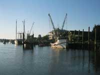 |
The creek was glassy except for patches where zephyrs of breeze would touch the surface, then lift away like a skipping stone. The shrimp boats’ nets hung limp in the dew.
|
|
After the first five nautical miles up the North Edisto, which took about an hour, the river turned just east of north. With the breeze building from the SSW, I handed the tiller to Joe and put up the spinnaker. This began the most incredible spinnaker run of the trip. We kept up the spinnaker the entire distance of nearly 20 nm from the Dawho River to Elliott Cut (known to the locals as Wappoo Cut). We covered this distance in 3 ½ hours, reaching Wappoo Cut at 12:30. We jibed a dozen times as the river changed direction. High tide coincided approximately with our arrival at Wappoo Cut which is the narrowest part of the ICW between Savannah and Charleston (about 40 yards across). The tidal currents are known to run 3 to 4 knots through here so it suited us to go through at high tide when the current would be minimal.
It is about 3.3 nm from Wappoo Cut to the Ashley River and Charleston Harbor, and we arrived in the Harbor at about 1:30. The wind was blowing 15 – 20 MPH in the, and the direction of the tide was opposite the wind, making for very choppy conditions in the harbor. I told Joe to take down the jib while I started to get the Honda ready. Joe quickly had the jib down, and I found that an H-12 simply does not sail well without its jib. The imbalance makes the boat want to point into the wind. Then I noticed that a really big ferry boat, the American Eagle, was being pushed sideways toward us by the wind while she apparently was waiting for her berth to be ready at the city Marina dock. The Honda was still stowed in the boat, the jib was down, and this 200 foot giant ship was drifting toward us at an alarming speed. I could not get Myrdie to bear away and pick up speed to get away from this looming monster. Soon the hull of the ship would shadow us from the wind, making a sailing escape impossible. There was not enough time to get the Honda mounted and cranked up. If we could not get away, the American Eagle would drift over us and not even know we were there. This was a very serious situation. I shouted to Joe, “Get up the jib!” pointing to the halyard attached to the middle cleat on the port side of the mast. He had it up in a jiffy, and we sailed out of the shadow of American Eagle with less than twenty yards to spare.
We mounted the Honda, cranked her up, lowered both sails, and motored safely into Charleston’s City Marina at 2 PM.
Charleston is a wonderful place to sail. The harbor is home to three yacht clubs (the Charleston Yacht Club on the west (Ashley River) side, Carolina Yacht Club and the east (Cooper River) side, and the James Island Yacht Club to the south across Highway 17 Bridge on James Island. I have had the pleasure of sailing out of all three clubs in regattas over the past fifty years, and there has almost always been great weather with plenty of wind, typically coming across the harbor from Fort Sumter. The Charleston Yacht Club adjoins Charleston’s City Marina, where we tied up for the night. Due to silt filling in, the Charleston Yacht Club hoist is functional only near high tide. High tide would be around 1 PM the following day, so drove early the next day to Beaufort to get my trailer for Myrdie, returning at noon for a rendezvous with member friends of mine at the club, Rear Commodore Scott Bartley and the ever generous and vivacious Sarah Ashton. Scott and Sarah expertly helped me hoist Myrdie from the waters of the harbor and bring her to rest on her trailer.
This concluded my little adventure of sailing from Savannah to Charleston in my H-12, Myrdie. It was a wonderful experience. I learned a lot. I enjoyed being with my friends as crews, and I have a special appreciation for friends who helped us get launched at the Savannah Yacht Club and get hoisted out at the Charleston Yacht Club. Most of all, I appreciate the cheerful support that I received from my wife, Alice, in driving the car, meeting us every night and taking us back to the boat every morning.
I want to do this again and have already checked the tides in 2006. The tides will be right for us again to start in Savannah in late April 2006. I cannot presume to have the support from the private clubs, but, if other owners of H-12s are interested in doing this, we can arrange alternate support sites, and I would enjoy having company on this very wonderful adventure on the ICW.

|