|
The Unexpected
Connecticut River |
|
| By Peter H Vanderwaart
- Stamford, Connecticut - USA |
I went up to Glastonbury the other day to look at
a 27-foot sailboat. An unlikely destination for such
a chore, Glastonbury is on the Connecticut River about
30 miles from open sailing water on Long Island Sound.
The boat was sad and neglected, but the river was
lovely. I thought to myself that most Duckworks readers
would have little idea of the river is like.
One of the great mother rivers of New England, the
Connecticut drains an area that includes central Connecticut,
west central Massachusetts, and large portions of
Vermont and New Hampshire. It is the largest flow
of water into Long Island Sound, and, neglecting the
influence of tides, the waters of the Sound east of
Saybrook flow east to Rhode Island Sound, and those
west of Saybrook flow west to Hellgate, New York Harbor
and the Atlantic.
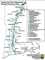 |
Map of the Connecticut
River
(click images
to enlarge) |
The River
Taking a quick look at a map of Connecticut, you
might imagine that the Connecticut River flows directly
south from Hartford along the highly developed central
corridor to New Haven. In fact, slightly south of
Hartford, the river veers east and flows through the
rural country side to the river mouth at Old Saybrook.
That’s 40 miles as the crow files. For this
discussion, we can divide the river into two sections:
the lower part from Old Saybrook to Essex, and the
upper part from Essex to Hartford.
The lower section is an important component on the
Long Island Sound yacht cruising circuit, and there
are a number of large marinas, such as the Old
Lyme Marina. The town of Essex,
about 6 miles upriver, has all a cruising sailor could
want for a stopover: big marinas, good restaurants,
shoppes, museums, theater, riverboats, and even a
steam train. Hamburg Cove, on the east side of the
river about a mile north of Essex is also a popular
cruising destination. I’ve been told the cove
is nearly paved with permanent moorings.
The upper section of the river is notable mainly
for the lack of development. From Essex to Hartford,
there is little industry visible from the river, except
for a couple of power plants (including the decommissioned
Connecticut
Yankee on Haddam Neck). The river varies
from 100 yards to a half mile in width. For most of
this section, hills rise almost directly from the
river itself, leaving little flood plain or bottom
land. Where there is room, the land is devoted to
agriculture, growing corn and tomatoes for Connecticut’s
roadside produce stands. There was a time when Connecticut
was the source of first quality cigar wrapping tobacco,
and a few of the tobacco aging barns can still be
seen. This section of the river is not yacht-oriented,
but there are many points of interest and plenty
for visitors to do.
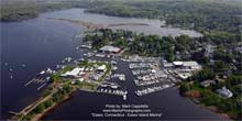
| Photo of downtown
Essex, CT. Marinas. |
|
There are number of state
parks along the river. I was interested
to see that the maps provided for Hurd State Park
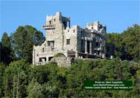
and Gillette Castle do not show the elevations. In
both places, the hills rise sharply from the river,
as can be seen in one of the photos here.
Hurd is primarily a forest area set aside for hiking
and picnicking, and the river views are gorgeous.
Gillette Castle is the legacy of the moderately eccentric
actor William Gillette. The castle is fun to tour,
especially with children who connect with Gillette’s
whimsy.
Although there are several boat ramps along the river,
I was not able to find a good list on the internet.
General information about boating in Connecticut is
provided by the state in the “Connecticut
Boater’s Guide”. (Confirm
the availability of any facilities that you wish to
make use of. I have seen conflicting information about
the availability of camping in some parks.)
The biggest town between Essex and Hartford is Middletown,
best known as the home of Wesleyan University. Yachtsmen
can get the services they need across the river in
Portland, CT. Some of the towns
along the river maintain parks with ramps or picnic
areas along the river, including Rocky Hill where
Lew Clayman and Dave Colpitts introduced me to Mouse
Boating.
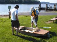 |
Lew on the left,
Dave on the right. The width and tree-lined
banks are typical of this stretch of the river. |
An interesting feature of the river near Hartford
is Wethersfield
Cove. This is a round pond about a third
of a mile across formed from an old bend (“oxbow”)
in the river. It connects to the river via a channel
running under bridges carrying I-91. Logically, it’s
the home for the Wethersfield Cove Yacht Club.
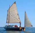
Boats
Two of the best ways to cruise the Connecticut are
by canoe, and by small powerboat.
Canoeing is popular on the river. It makes sense
to canoe downstream, of course, to take advantage
of the current. The lower river, being navigable by
large vessels up to Hartford, is all flat water. There
is white water on the upper Connecticut River. (The
best white water in the State of Connecticut is on
the Housatonic
River.) There are places to camp, and
it makes sense to plan ahead as best you can.
Powerboats of all sorts use the river. For the visiting
cruiser, a good choice would be a low-powered outboard
with a quiet, 4-stoke. A Bolger Tennessee would do
very well.
Sailboats should research the bridges along their
route. They are either high, or will open to permit
passage.
| Glillette Castle
State Park in East Haddam, CT |
|
Navigation
I had a chat with my friend Bernie
Weiss about the difficulties of navigation
on the Connecticut. His advice boiled down to three
considerations: silt, current, and commercial traffic.
The river water is light brown due
to the silt it carries from upstream, and drops
just about anywhere. (There area also other typical
river hazards such as floating debris and half-soaked
logs.) The Coast Guard keeps the channel dredged
and well marked, but elsewhere the water may be
very shallow and the depths unpredictable. At the
mouth of the river, there is big shoal area to the
east of the dredged channel. West of the river,
silt has built Long Sand Shoal, a hazard that is
well marked and clearly shown on charts. In the
river itself, boats with moderate or deep draft
are advised to stay in the channel. As always, make
sure your charts are up-to-date.
The current in the river is influenced
by both weather and tide. In normal weather, the
average current near Hartford is between one and
two knots, but may be more after a heavy rain. (In
the early spring, there is a period of much stronger
current due to snow melt in northern New England.)
The average depth also varies. Information on the
state of the river is available from NOAA.
At Old Saybrook, the rise and fall
of tide is about 3 feet, and tidal currents are
significant. As you go up the river, the proportion
of ebb time increases and the proportion of flood
time diminishes, however the flooding current may
be surprisingly strong. Note that current may flow
across the line of the channel pushing a boat into
undredged shallows; this is especially true at the
river mouth.
Commercial traffic on the lower Connecticut
is mostly in the form of barges, either self-propelled
or pushed by tugs. They stay in the channel, and
are in many cases so big they seem occupy the channel
completely. Skippers should be alert at all times
since they may appear at any time going surprisingly
fast. Bernie strongly recommends that recreational
boaters stay off the river at night due to heavy
commercial traffic. He also recommends fighting
the urge to cut back to the center of the channel
in the wake of a barge because deep draft barges
and the large tugboat propellers churn up all manner
of neutrally buoyant objects from the bottom.
Any time in the summer would be good
for visit, but it strikes me that if your significant
other wants to see New England foliage, and you
want to go boating, the Connecticut River can supply
both at once. In Connecticut, plan for the third
week in October for maximum color.
|